News Article
November 18, 2014
Since 1999, more than 10,000 organizations worldwide have hosted GIS Day. On Nov. 13, iUTAH participated as the Utah Valley Geographic Information Systems (GIS) Group hosted a GIS Day event at Utah Valley University (UVU). The program included 2 tracks: one for 4-6 graders and one for junior high and high school students. Elementary students had the opportunity to experience hands-on exercises that taught them about maps, GIS, GPS, and remote sensing (aerial, and satellite imagery). The high school students attended a career panel with the opportunity to explore online maps and interact with GIS professionals. Vendors and projects had booths outside the events to continue enhancing the student experience.
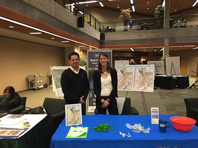
Utah Valley University faculty members organized the Utah Valley GIS (UVGIS) Group, composed of academic and private and public agencies in Utah that use GIS to solve a variety of problems including water conservation, resource management, elections, sewer management, population analysis, transportation planning, economic development, urban projections and planning, telecommunication network analysis, and more. Among the founders is UVU Assistant Professor Suzanne Walther (pictured along with iUTAH research associate Samuel Rivera), who hosted the event. The iUTAH booth featured Utah's water map in English and Spanish. We answered questions about iUTAH and Utah’s water from numerous visitors in both the elementary and secondary school groups.
« Back to list of all news articles