About the Observatory
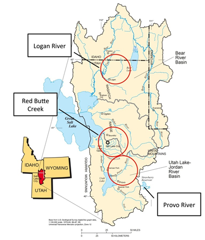
The iUTAH Socio-Environmental Observatory was constructed with funds provided by NSF EPSCoR, (award # OIA-1208732, iUTAH: innovative Urban Transitions and Arid-region Hydro-sustainability). Spatially, the observatory spans the Wasatch Front, with environmental monitoring instrumentation installed in three watersheds that differ in the biophysical and human dimensions and the nature of land-use change (See map). Instrumentation was installed along a mountain-to-urban gradient in each watershed. Within each watershed, four core terrestrial stations used the following sensors: Vaisala PTB110 barometer, Vaisala air temperature and humidity, RM Young anemometer, Kipp and Zonen CNR-4 net radiation, Apogee quantum sensor, Judd ultrasonic snow depth sensor, Geonor weighing precipitation gauge, six Campbell Scientific water content reflectometers (soil moisture), and six heat flux plates (built in-house). Some stations were equipped with Vivotek fixed-time lapsed cameras and sapflow sensors (built in-house). All sensors were connected to Campbell Scientific data loggers (either CR1000 or CR3000-RC) and transmitted data records via either RF450 900MHz radio transmitters or RAVEN cellular digital modems to the iUTAH Modeling and Data Federation at 15-minute time intervals.
Five core aquatic stations were installed along elevation gradients in the Logan River and Red Butte Creek watersheds, while four core aquatic stations were installed along a similar elevation gradient in the Middle Provo River watershed. These stations used Xylem (YSI) EXO2 data sondes with pH, electrical conductivity, temperature, dissolved oxygen sensors, a Forest Technology Systems turbidity sensor, and a Campbell Scientific pressure transducer. Two stations in each stream were enhanced with additional EXO fDOM and total algae sensors, as well as a Satlantic SUNA nitrate sensor. Flows in several storm drains and/or irrigation canals were monitored using ISCO flow level sensors. As with terrestrial stations, the aquatic station sensors were connected to Campbell Scientific data loggers (CR800) and transmitted data records via either RF450 900MHz radio transmitters or RAVEN cellular digital modems to the iUTAH Modeling and Data Federation at 15-minute time intervals. Data can be downloaded and visualized online.
Social science data collection used the footprint of the sensor network for their efforts. These included detailed neighborhood typologies constructed using parcel-scale land use-land cover, and other secondary data sources including water use and socio-demographics. The neighborhood typologies were used to select twenty-three neighborhoods in twelve cities in three counties (representing 42% of the Utah population) for drop-off/pick-up household surveys in each watershed (approximately 4140 households). The response rate was high (62%), yielding 2343 useable respondents from 3766 eligible households. (View Data Summaries) A subset of questions from the household survey was distributed across the state using iPads in a random intercept of adults in public spaces resulting in over 9,000 responses to eight collection efforts. (Explore Data)
The cyberinfrastructure (CI) of iUTAH supported and integrated diverse data collection of the socio-environmental observatory. Through collection, merging, and modeling tools of CI, a statewide audience of stakeholders became engaged with the broader efforts of water and STEM-related issues in the state.